Lecture 5 – Measurement and navigation in war
From the 1981 lecture programme:
Both in peace and in war men need to know where they are on the surface of the earth, and – nowadays – in space.
The first major requirement for precise navigation was at sea, where the captain of a ship needed to know where his ship was so as to work out the way to his destination, and also where it was relative to rocks or shoals which could wreck him. Once it was recognised that the earth was roughly a sphere, the position of any point on it could be defined by longitude and latitude. By observing the positions of sun and stars at known points on the earth throughout the year, and comparing the positions as seen at his ship, the captain could easily tell his latitude. But to tell his longitude he had in principle to be able to measure the time interval between noon at Greenwich and noon where he was. Until recently the only way of doing this was to have a clock which he could take anywhere in the world which would stay constantly keeping Greenwich time. For this purpose the chronometer was invented, and was first used successfully in the 1760s.
Now that radio waves are available to travel round the earth, Greenwich time can be transmitted everywhere with a delay of less than a tenth of a second, and so the chronometer, although helpful, is no longer necessary. And if we transmit waves simultaneously from three different points, we can work out where we are by noting the time intervals between the waves reaching us, much like the hyperbolic method of gun location mentioned in Lecture IV. And we can place the transmitters in satellites to overcome difficulties created by the inability of short radio waves to bend round the curvature of the earth. The Americans are just installing the NAVSAT system of satellites which will enable an observer to establish his position on the earth to within ten metres, even though the satellites are some thousands of miles away and are moving at about eighteen thousand miles an hour.
Perhaps unfortunately, as with so many inventions, improvements in navigation are two-edged, for the same principles which enable us to navigate precisely can also be used to drop bombs, or to aim missiles, at targets. Radio techniques, such as the intersecting beams used by the Germans in World War II, could be used to guide bombers to their targets; and such techniques have been developed to enable intercontinental rockets to be aimed within a few hundred yards of their targets at ranges of eight thousand miles.
Although radio methods can sometimes be countered by sending false signals to confuse the aircraft or missile, there is another method of navigation which depends only on instruments carried in the aircraft itself. For this we have to measure the acceleration of the aircraft continuously from its take-off. By adding up all the cumulative effects of the accelerations up to a particular instant, we can tell the velocity of the aircraft at that instant, and then by adding up all the velocities, we can tell how far and in what direction the aircraft has moved from its starting point, and so we can know where it is relative to its destination or target. This is inertial navigation, which was first developed for the German V2 rockets, and can be applied both to rockets and cruise missiles as well as to civil and military aircraft.
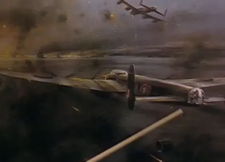
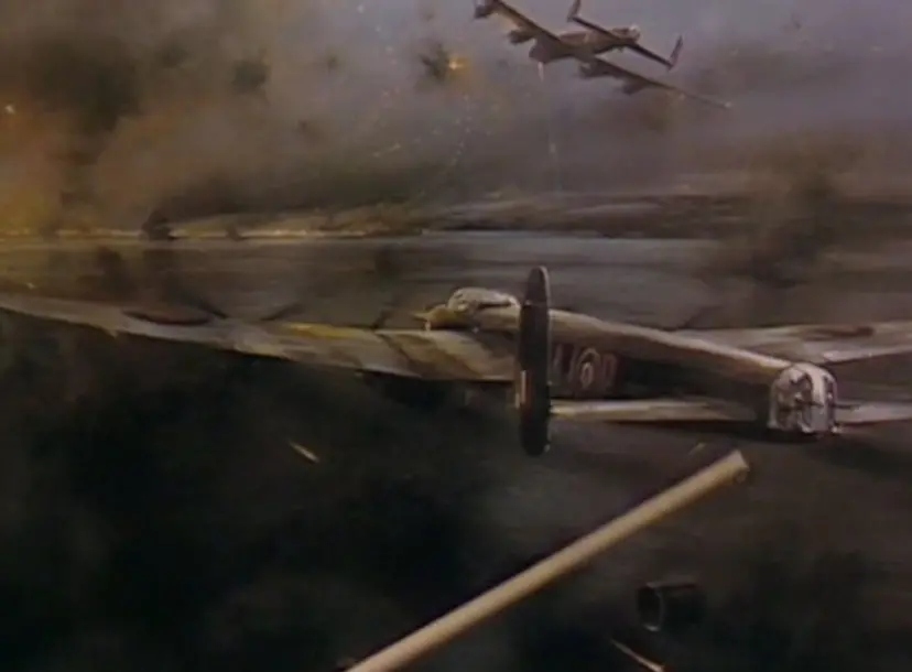
Simple measurements can also be valuable in warfare especially since their simplicity may make them less vulnerable to countermeasures, and once again ingenuity may give more satisfactory results than sophisticated instructions. We shall see the methods by which the Dam Busters estimated the correct distance at which to release their bouncing bombs and to fly accurately at very low level.
About the 1981 CHRISTMAS LECTURES
From the 1981 lecture programme:
The Christmas Lectures at the Royal Institution started in 1826, and there have now been more than one hundred and fifty in the series; and yet none has previously been on the theme of this year's lectures, which is measurement. Perhaps this is because the measurement is so much part of human life that we tend to take it for granted; but if we are to understand how our modern world, with all its achievements and its dangers, has evolved, then we need to know what measurement is, the principles by which measurements can be made, and why their applications have been of so much importance in the advance of science and in the development of technology. And we also need not be carried away by the spectacular successes of measurements, such as awakening mankind to the huge store of energy in the atomic nucleus, or the microchip, or the control of space probes as far away as Saturn; for despite Plato's proud claim that 'man is the measure of all things' there are many qualities in life that are very difficult, if not impossible, to measure such as love or courage, and we should therefore be cautious about extending measurement beyond its proper domain. But within that domain, measurement is one of the most challenging, fascinating and rewarding of human activities: this is what the lectures are intended to show.